
The Hike before the Hike: 5 NY/NJ Hiking Trails Accessible by Public Transportation
So, you live in New York City, want to hike, but don’t have a car. As someone who’s been in your hiking boots, I get it. Living in a mega-urban setting like NYC, I've always craved a deeper connection with nature, but also felt like my options were always limited without a car. Yes, there are trees and local parks, but nothing like the forests you see in movies or the mountains over the horizons you pass while driving on the highway.
In 2022, I decided to stop daydreaming about the atmosphere of the deep woods and start chasing it. I made a couple of google searches, specifically for more fully- immersive trails away from the noise of the city. I connected the dots with my phone’s GPS and found that getting to hiking trails that only seem accessible through Instagram reels is actually easier than you think.
There are plenty of trails upstate that are accessible by public transportation. Here are 5 New York/New Jersey hiking trails that I've had the pleasure of embarking on without a car, and the mistakes I made along the way so you don’t have to.
Hiking the MTA: Metro North & NJ Transit
First, I'll start with the hiking before the hike. I know a lot of New Yorkers have a toxic relationship with commuting, but you can absolutely consider navigating your way to the hike as part of the fun. The views on the way to the trail will make you forget you haven’t even started yet.
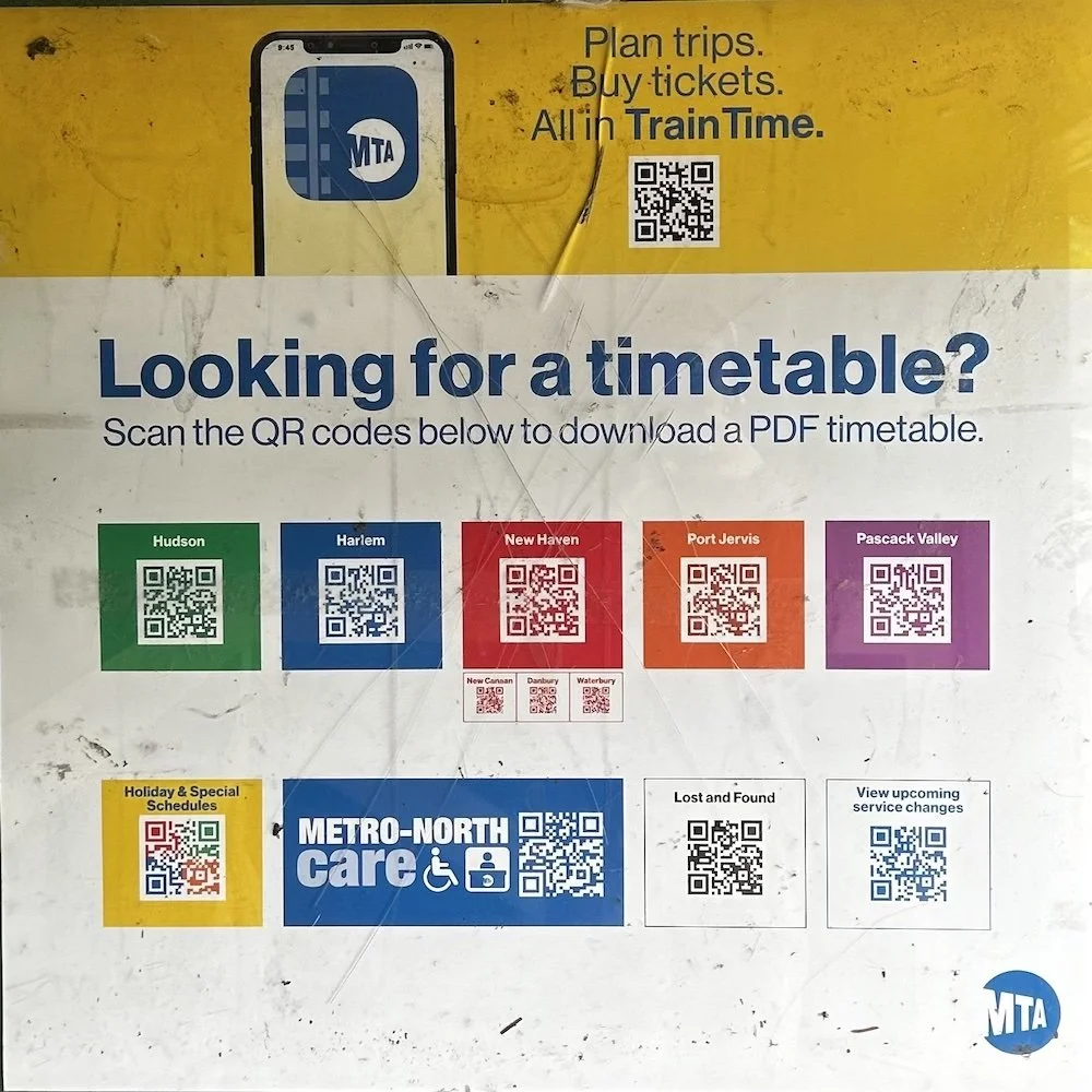
To run away from the city and into the woods listed below, you can take the Metro North Hudson line (the green one), or The New Jersey Transit Morris/Essex line. I highly recommend downloading the “MTA TrainTime” and “NJ Transit” apps. You can search round trip train times and buy tickets right on the app. The Metro North leaves from various stops in the city. Enter the nearest one to you into the MTA train app to see what transfers, if any, you’ll have to make. Fares to reach each trail from the city range around $30-35.50 roundtrip. Each train ride is around 1-2 hours depending on your origin.
Manitou Station
I’d say the most important thing to pay attention to are the restrictions for different train stops. Some trains only stop at certain stations on the weekends or at limited times throughout the day. Only specific train cars may open at certain stations as well. Keep reading to learn the restrictions per trail. Whether I was aware of these restrictions before hiking the trails is a different story. For the trails that don’t have restrooms, be sure to go on the train. Ask a conductor or play musical cars until you find the next one with a restroom. If you find yourself in a potty emergency on the trail, be quick in fertilizing the soil—these trails tend to have a lot of bugs.
Tip: When hiking the Metro North, sit in the 3-seater row on the way there and in the double-seats on the way back to get the water/mountain view both ways. Plan to head back around sunset for the perfect orange hues and views to end a great hike.
Hiking Trails & Details
Bull Hill Short & Full Loop
Difficulty: Moderate- Difficult
Distance: Short loop (4.3 miles), Full loop (5.4 miles)
How to get there: Metro North Hudson Line to Cold Spring
Restrooms: At the station ticket booth
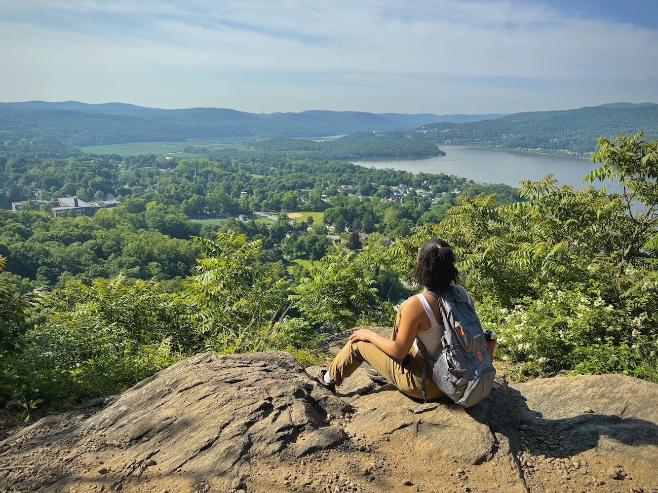
After getting off at Cold Spring Station, follow the signs down the straight path into town, then set your GPS to “Bull Hill Full Loop.'' It's about a 20 minute walk to the trailhead. Staff are usually there on the weekends should you have any questions. You can decide which loop you would like to finish on the trail. The short loop was a no-brainer for me my first time as I was already wheezing before reaching the sign to choose which loop to continue on. It’s a steep uphill start for about 15 minutes either way so make sure it’s leg day!
2. Mount Beacon
Difficulty: Moderate- Difficult
Distance: 6 miles
How to get there: Metro North Hudson line to the “Beacon” station. Then transfer to the Trolley bus to trailhead
Restrooms: No
I’d say this is the most complicated commute on the list, but for the city-living adventurer, it’s absolutely worth it. After getting off at Beacon Station, take the Trolley bus right outside the station. It will leave you right at the trailhead. You can ask the bus driver to tell you when to get off. It’s a tiny bus stop (black metal gazebo) so enter “Cold Spring Trolley Bus” into your GPS if you can’t find it when you get off the train.
It’s a small town so you’ll have to hail the bus on your way back. Check the bus route here if you get lost. I didn’t know this and walked 30 mins to the nearest stop my GPS picked up, then sat awkwardly on what I'm pretty sure was someone’s front lawn while waiting for the next bus. I then realized you can also walk 38 minutes back to the station. Lots of firsts that day.
Fun fact: Mount Beacon is the highest point in the Hudson Highlands!
3. Rahway (White) and River Trail
Difficulty: Easy-Moderate
Distance: 4.5 miles out and back
How to get there: NJ Transit Morris & Essex line to Milburn or South Orange
Restrooms: No
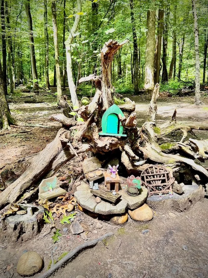
To reach this wonderland, take your nearest train to Penn Station and transfer to the NJ Transit Morris & Essex Line train (towards Dover). Exit the train at Milburn and enter “South Mountain Fairy Trail” into your GPS. It should be less than a 5 minute walk to the trail head. You can also start from Hemlock falls and end the trail with the fairy houses. For this route, take the same train to the South Orange stop and enter “Hemlock Falls” into your GPS. It’s about a 35 minute walk to the trailhead.
This is by far the most adorable hiking experience I've had yet. I couldn’t help but stop and smile at each of the adorably detailed little fairy houses and wonder, how much is rent?
4. Breakneck ridge
Difficulty: Hard
Distance: 5.7 miles
How to get there: Metro North Hudson Line to Breakneck Ridge
Restrooms: No
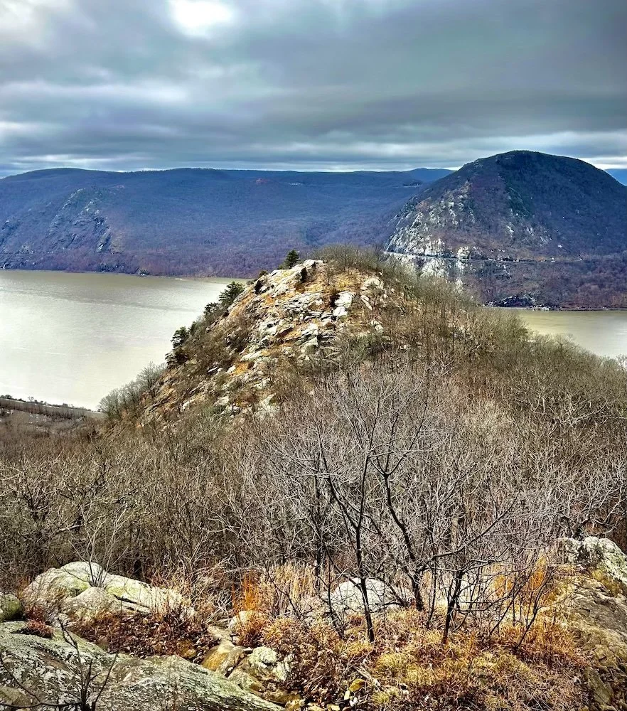
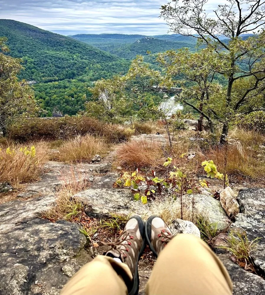
Tossing Breakneck Ridge in here for seasoned hikers, and seasoned hikers only. I had read in another blog that this was ranked hard/for experienced hikers and I was like “I’ve been on like 3 long hikes, I got this…” Instead, the hike got me. While I received a lot of confirmation that the trail certainly lives up to its name, I also saw what I’d say are the best views of all Hudson Highland trails on this list.
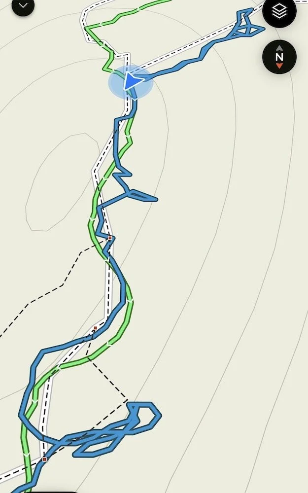
Very important to note that the Metro North only stops at this station on the weekends and the doors for this stop only open within the first 3 cars of the train. The train runs from around 7am to 1pm from the city to Breakneck, and from 3pm to 7pm from Breakneck back to the city. I know this not because I was responsible and checked ahead of time, but because I waited 2 hours in the January cold after learning said information. It gave me time to process that journey however, keep reading to see my massive detour whilst lost on trail.
5. Anthony’s Nose
Difficulty: Moderate- Difficult
Distance: 2 miles
How to Get There: Metro-North Hudson Line to Manitou
Restrooms: No
Certainly the most daring, yet the most beautiful commute on this list. Anthony’s Nose trail head is about a 40 minute walk from the Manitou station, but the views absolutely make this part of the hike. About 20 minutes in, you’ll have to walk on the side of the road up to the trailhead. I know it sounds scary but there is enough space to walk safely. However, I recommend planning to do this hike in the early morning to avoid a lot of passing cars. I got to Manitou around 9am. The trailhead is just off the side of the road, a cute little information hut you can’t miss. Expect a steep uphill start of about 30 minutes.
Make sure you’re in the first car of the train, as it is the only one that opens for this stop. Once you’re off, set your GPS to the Anthony’s Nose trail head and follow the straight path. It's nearly impossible to get lost, as the train quite literally leaves you on the tracks and there’s nowhere else to walk but straight ahead.
Tip: About 10 minutes in you’ll notice the Manitou Point Nature Preserve to your left. It’s a cute serene path open to the public. I had time to kill and checked it out on my way back. It was a fantastic end to a beautiful hike. Beware of ticks!
Additional Tips & Resources:
Downloading the AllTrails app prior to hiking any trail is a must. It’s basically a trail GPS to help you stay on route and you can access it without cell service if you have a subscription. Plug in the name of any of the trails on this list, hit navigate, then start. You can also read the comments to see what to expect throughout the different seasons and find similar or nearby trails you may also want to try.
A lot of these locations have multiple trails with different distances and difficulties. You can scroll through the options on All Trails and pick whatever you feel called to. I enjoy long and challenging hikes, but there are shorter, less strenuous trails at each of these locations. Fair warning though, some trails have not been updated and therefore are not entirely accurate. Learned that the hard way too. See extreme detours during my first time hiking Breakneck Ridge below:
For crowd-avoiders like me, I recommend catching the train from 8-10am. Although sometimes, hiking with a few crowds is helpful if you’re a solo/beginner hiker. It was helpful for me on my very first solo hike to Bull Hill, as I still wasn't too experienced with following markers. I definitely would have gotten lost if there weren’t so many people on the trail to follow at a safe-enough distance that didn’t make me a creep.
Keep in mind that a longer hike doesn’t always mean better views. This was a disappointing realization after finishing the Bull Hill Full Loop, and continuing to look for the view. Also, pack light, but don’t underestimate how much water you’ll need.
Closing the Loop
As a city resident, you can always prove how no car is no excuse. Not only is it possible to get to more immersive hikes outside of the city, but it's incredibly rewarding. The journey to these hikes offers a peaceful escape from the city and a chance to slow down before you hit the trail. While on the train, I like to read, journal, or stare out of the window admiring the views, and remembering that I do like this little life.
Whether it's surviving the steep inclines of Breakneck Ridge or strolling through the whimsical fairy houses on the Rahway Trail, each hike has something unique to offer – and they’re closer than you may think. With a little planning, you can enjoy the full experience without the stress of traffic and parking.
Looking for more adventure? Learn exactly what you seek in the Adventure Seeker blog, and subscribe to Souleyness for more adventure tips.
Happy Adventurousness!